Unveiling the Real Size of Africa: What You Need to Know in 2025
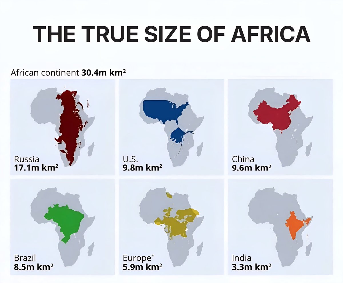
Throughout history, maps and world representations have often distorted the true scale of continents, leading to misconceptions about their size and significance. In 2025, as global perspectives evolve with new cartographic insights, many are starting to realize just how vast and diverse Africa truly is. Here are six important facts revealing the genuine size of the continent, dismantling common myths and emphasizing Africa’s rightful place on the world stage.
1. Africa Covers Nearly 12 Million Square Miles
When compared to other continents, Africa is undeniably massive. Spanning approximately 11.73 million square miles (30.37 million square kilometers), it ranks as the second-largest continent after Asia. Its sheer expanse means that it is home to an incredible array of climates, ecosystems, and cultures. From the deserts of Sahara to the lush jungles of Congo, Africa’s terrain is as diverse as its people.
2. Africa Is Bigger Than the United States, China, and Europe Combined
One common misconception fueled by traditional maps is that Africa is smaller than many European countries or the U.S. However, in reality, Africa’s landmass surpasses the combined area of the United States (around 3.8 million square miles), China (around 3.7 million square miles), and most of Europe (about 3.9 million square miles). This enormous size underscores Africa’s significance as a continent with profound influence on global economics, politics, and culture.
3. The Map Distortion Myth: Africa’s True Size Is Often Underestimated
Many world maps, especially those employing the Mercator projection, distort the size of landmasses, making regions near the poles appear larger while shrinking equatorial regions like Africa. This distortion has historically led to underestimating Africa’s actual size. Recent advancements in cartography and 3D mapping technology reveal that Africa is often underrepresented in size when viewed through traditional maps, emphasizing the importance of updated visuals for an accurate understanding.
4. The Sahara Alone Could Cover Several US States
The Sahara Desert, the largest hot desert in the world, spans about 9.2 million square miles — roughly the size of the United States. This immense desert stretch is only part of Africa’s vast geography. Such a perspective helps illustrate Africa’s geographic diversity, including expansive deserts, rainforests, savannas, and mountain ranges, each covering significant landmass.
5. Africa’s Countries Vary Drastically in Size
Africa comprises 54 countries, but their sizes differ widely. Algeria, the largest country on the continent, covers over 2.38 million square kilometers, while countries like Seychelles and São Tomé and Príncipe are tiny in comparison. Understanding these disparities is crucial in appreciating Africa’s diverse demographic and economic realities. It also highlights why regional development strategies must be tailored to the specific needs of each nation.
6. Africa’s Population Could Double by 2050
With a current population exceeding 1.4 billion in 2025, Africa’s population growth rate is among the highest globally. Experts project that by mid-century, Africa’s population could almost double, reaching nearly 2.5 billion people. This growth emphasizes the importance of sustainable development, infrastructure expansion, and resource management to accommodate the demographic changes and harness the continent’s demographic dividend.
These facts serve as a reminder that Africa is a continent of enormous size, diversity, and potential. Moving away from outdated maps and misconceptions allows for a more accurate appreciation of its role in shaping the future of our interconnected world. As world leaders, educators, and viewers, understanding Africa’s true size and scope is crucial for fostering respect, collaboration, and growth.
Published in 2025, this overview aims to promote a better understanding of Africa’s actual geographic significance as the world continues to evolve.