Tag: tsunami

  • Rain and aftershocks hinder rescue efforts as Philippine quake reaches 55 deaths

    Rain and aftershocks hinder rescue efforts as Philippine quake reaches 55 deaths

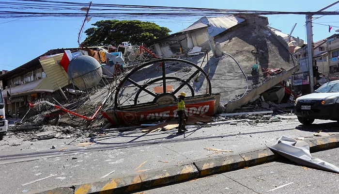
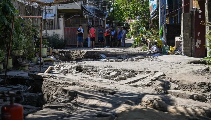
    Rescuers in southern Philippines worked through rain and aftershocks on Friday, clearing roads and searching for missing persons as the death toll from a powerful earthquake climbed to 55. The 7.8 magnitude quake struck just off the coast of Mindanao on Monday, causing buildings to collapse, landslides to occur, and triggering tsunami alerts across the region.

    A government report released Friday confirmed eight new fatalities, with 31 people still missing as local authorities continued to gather reports. In Sarangani province, which was severely affected, provincial disaster officer Rene Punzalan told AFP that many blocked roads had been reopened, but helicopters remained essential to deliver food and water to residents cut off from supplies and still without power.

    “Aftershocks are slowing our progress, and it rained last night, so we’ve had to halt some operations,” Punzalan explained, noting that heavy equipment was being used to move large boulders blocking the roads. He also expressed little hope of rescuing survivors, stating, “Many days have passed since the earthquake, so it would be a miracle if anyone is still alive. Our main focus now is to recover bodies.”

    Philippine President Ferdinand Marcos visited the affected areas of General Santos—largest city in the region—including a damaged school and a relief distribution point. He announced that the government would allocate 100 million pesos ($1.6 million) to rebuild the city hall.

  • Philippines Earthquake Deaths Surge to 46

    Philippines Earthquake Deaths Surge to 46

    A damaging earthquake with a magnitude of 7.8 struck off the coast of Mindanao, Philippines, on Monday, causing buildings to collapse and triggering landslides. Tsunami alerts were issued across the southern region. By Wednesday, rescuers recovered a body from the rubble of a supermarket in General Santos City, raising the death total to 46. Joey Deluvio, 39, was among two workers at the store still being searched for after the disaster. Rescue teams detected faint signs of life earlier, but unfortunately, his body was ultimately found trapped between two beams. The official death toll from the national disaster agency increased to 45, with the number of missing persons rising from four to 17. Deluvio’s death was not included in the official count. Most casualties occurred in Davao Occidental, primarily from landslides and structural collapses, according to civil defense authorities.

  • Latest: Magnitude 6.2 Earthquake Hits Hokkaido, Japan

    A powerful earthquake struck northern Japan’s Hokkaido island early Monday, according to both US and Japanese weather agencies, marking the latest in a series of seismic events affecting the region. The earthquake registered a magnitude of 6.2 and hit at 5:23 a.m. local time (Sunday 9:23 p.m. GMT) in the southern part of Hokkaido. The Japanese Meteorological Agency (JMA) revised its initial estimate of magnitude 6.1 to 6.2, with the quake occurring at a depth of 83 kilometers (52 miles).

    No tsunami warning was issued by JMA, and the U.S. Geological Survey indicated that damage to property and risks to life were expected to be minimal due to the low population density in the area, situated roughly 200 kilometers east of Sapporo. However, officials noted that areas subject to intense shaking could face increased hazards like falling rocks and landslides. JMA also warned that the probability of additional quakes of similar strength in the coming week remains high.

    Earlier that day, a magnitude 5.0 tremor occurred offshore, several hundred kilometers south of Hokkaido. These events come shortly after JMA issued warnings of an elevated risk of a major quake—an 8.0 magnitude or greater—following last Monday’s 7.7 magnitude earthquake off northern Iwate Prefecture. That quake injured six people and caused significant shaking in Tokyo, hundreds of kilometers from the epicenter. It also triggered 80-centimeter (31-inch) tsunami waves in a port in Iwate, with smaller waves occurring elsewhere in northern Japan.

    Following the Iwate quake, JMA stated that the likelihood of a new, large-scale earthquake in the region was higher than usual. Japan remains one of the most seismically active countries globally, situated atop four major tectonic plates along the Pacific “Ring of Fire.” The country, home to about 125 million people, typically experiences around 1,500 earthquakes annually, accounting for roughly 18% of the world’s seismic activity.

    The nation holds the tragic memory of the massive 9.0 magnitude undersea quake in 2011, which caused a devastating tsunami resulting in approximately 18,500 deaths or missing persons and triggering a nuclear meltdown at Fukushima.

  • Six Hurt in Japan Quake, No Major Damage Reported

    Six Hurt in Japan Quake, No Major Damage Reported

    A powerful earthquake struck northern Japan, resulting in injuries to at least six individuals reported by Tuesday. The tremor also generated tsunami waves reaching up to 31 inches (80 centimeters). Fortunately, there was no significant structural damage observed.

    The Japan Meteorological Agency (JMA) issued a warning about a heightened chance of a megaquake—an earthquake with a magnitude of 8.0 or higher—following Monday’s 7.7 magnitude quake offshore in Iwate Prefecture. The quake was strong enough to shake large buildings in Tokyo, hundreds of miles away from the epicenter.

    By 8 a.m. local time (11 p.m. GMT Monday), the Fire and Disaster Management Agency confirmed six injuries, with two categorized as severe. No fires or critical facility damages were reported. A tsunami warning for waves up to three meters (10 feet) was issued but was lifted after an 80-centimeter wave struck the port of Kuji in Iwate, along with a series of minor waves in the region.

    The JMA indicated that the likelihood of a major earthquake occurring soon has increased compared to normal times. Local authorities advised non-mandatory evacuations for over 182,000 residents in affected areas.

    Japan, situated atop four significant tectonic plates along the Pacific “Ring of Fire,” remains one of the world’s most seismically active nations. The country, home to approximately 125 million people, experiences around 1,500 earthquakes annually, accounting for nearly 20% of the world’s seismic activity. Most quakes are minor, but their impacts depend heavily on location and depth beneath the Earth’s surface.

    The memory of the catastrophic 9.0 magnitude undersea earthquake in 2011 still lingers. That disaster triggered a tsunami that claimed or left missing about 18,500 people and caused a severe meltdown at the Fukushima nuclear plant.

  • 7.5-Magnitude Japan Quake Triggers Tsunami Alert

    7.5-Magnitude Japan Quake Triggers Tsunami Alert

    An earthquake with a magnitude of 7.5 struck off Japan’s northeastern coast on Monday, prompting authorities to advise residents to avoid coastal zones, as tsunami waves of up to 3 meters (around 10 feet) are anticipated. The epicenter was located in the Pacific Ocean, about 10 kilometers deep, according to the Japan Meteorological Agency. The most significant waves are predicted to impact Iwate, Aomori, and Hokkaido prefectures.

    Prime Minister Sanae Takaichi addressed the public, stating that a state of emergency has been declared with an emergency task force in place, urging those in vulnerable areas to evacuate immediately. Japanese broadcaster NHK showed ships leaving Hachinohe port in Hokkaido to escape the incoming waves, with emergency alerts warning, “Tsunami! Evacuate!”

    Train services in Aomori, at the northern tip of Japan’s Honshu island, have been halted following the quake, as reported by Kyodo News. The earthquake registered as a level “upper 5” on Japan’s seismic intensity scale, indicating strong shaking that can hinder mobility and cause unreinforced concrete walls to collapse.

    Japan is notorious for its seismic activity, experiencing quakes approximately every five minutes due to its location within the Pacific “Ring of Fire,” which encircles the Pacific Basin with active volcanoes and oceanic trenches. The country accounts for roughly 20% of all earthquakes worldwide measuring magnitude 6.0 or greater.

    While no nuclear power plants are currently operational in Hokkaido and Tohoku, some facilities have been shut down for safety reasons. Hokkaido Electric Power and Tohoku Electric Power are assessing the earthquake and tsunami’s impact on their nuclear installations, including the Onagawa plant operated by Tohoku Electric.

  • Tsunami Alert Sent Following 7.8 Magnitude Quake Off Indonesia

    Tsunami Alert Sent Following 7.8 Magnitude Quake Off Indonesia

    A magnitude 7.4 earthquake struck the northern Molucca Sea near Indonesia’s historic spice island of Ternate on Thursday, according to the United States Geological Survey. This quake prompted a tsunami warning for neighboring Southeast Asian countries. No immediate injuries were reported, but aftershocks reaching up to magnitude 5 were felt. Indonesia has issued tsunami advisories for parts of North Maluku and North Sulawesi provinces.

    Local authorities in Ternate and Tidore, the former spice islands, have been advised to prepare residents for potential evacuations. Images broadcasted on Metro TV showed damage to buildings in affected areas. The USGS revised the quake’s initial magnitude from 7.8 down to 7.4 and indicated it occurred at a depth of 35 kilometers (about 22 miles), deeper than the earlier estimate of 10 kilometers (6 miles).

    The quake’s epicenter was approximately 120 kilometers (75 miles) from Ternate, a city with a population of over 200,000. Tsunami threats extend to the coasts of Indonesia, the Philippines, and Malaysia within 620 miles (1,000 km) of the epicenter. The Pacific Tsunami Warning Center predicts waves between 0.3 meters and 1 meter (roughly 1 to 3 feet) could impact some Indonesian coastal regions, while smaller waves under 0.3 meters (about 1 foot) might reach the shores of Guam, Japan, Malaysia, Papua New Guinea, the Philippines, and Taiwan.

    Japan’s meteorological agency warned that waves up to 0.2 meters (around 8 inches) are possible, but no damage is expected. Indonesia’s location along the Pacific Ring of Fire—an area of significant seismic activity where tectonic plates converge—means earthquakes are frequent in the region.

  • 7.6 Magnitude Quake Off Japan Sparks Tsunami Alert

    7.6 Magnitude Quake Off Japan Sparks Tsunami Alert

    A powerful earthquake hit Japan’s northern coast on Monday, prompting the country’s meteorological agency to record two tsunami waves, each measuring 40 centimeters. Local media reported some injuries as the quake caused widespread disruption.

    According to the United States Geological Survey, the quake had a magnitude of 7.6 and struck at 2:15 p.m. GMT off Misawa on Japan’s Pacific shoreline, at a depth of 53 kilometers (about 33 miles). The Japan Meteorological Agency issued a tsunami warning, with the initial wave reaching a port in Aomori, near Misawa, at 11:43 a.m. local time (2:43 p.m. GMT).

    Later, at 11:50 p.m., another 40-centimeter wave arrived in Urakawa, in Hokkaido. Photographs and footage captured shattered glass scattered across roads, indicating the significant impact. In Hachinohe, a hotel staff member confirmed injuries, and images showed debris and broken glass cluttering the streets.

    The tremor was also strongly felt in Sapporo, where residents received alerts on their smartphones. An NHK reporter in Hokkaido described the quake’s horizontal shaking lasting about 30 seconds, making it impossible to stand.

    Early warnings from the meteorological agency suggested that a tsunami of up to three meters (around 10 feet) could hit Japan’s Pacific coast. Japan’s location atop four major tectonic plates along the Pacific “Ring of Fire” makes it one of the world’s most tectonically active nations. With roughly 125 million residents, the country experiences about 1,500 tremors annually—most are mild, but their effects can vary dramatically depending on their strength and depth underground.

  • Six Dead After Major Earthquake Rocks Southern Philippines

    Six Dead After Major Earthquake Rocks Southern Philippines

    A powerful 7.4 magnitude quake struck off the southern coast of the Philippines on Friday, resulting in a minimum of six fatalities and prompting tsunami alerts that were eventually canceled. The earthquake occurred approximately 12 miles (20 km) offshore near Manay town in Mindanao at 9:43 a.m., according to the US Geological Survey. Just over a week prior, a magnitude-6.9 quake in Cebu province caused 75 deaths and injured over 1,200.

    Rescue teams are working tirelessly to access isolated mountainous regions affected by the tremor. In the mountains west of Manay, three miners trapped in tunnels when the shafts collapsed have been confirmed dead; one miner was rescued alive, and several others sustained injuries. Rescue efforts are concentrated in Gumayan, a remote area only reachable by dirt bikes. In Mati city, the nearest major urban center to the epicenter, one person died due to a collapsing wall, and another died from a heart attack. Davao city, over 60 miles (100 km) away, also reported a fatality, though details remain unclear.

    In the immediate aftermath, Philippine authorities issued a tsunami warning, evacuating residents along the eastern coast where waves up to three meters (roughly ten feet) were feared. The Pacific Tsunami Warning Center canceled the alert around midday, confirming that the threat had subsided.

    Eyewitnesses described scenes of chaos, with people fleeing in panic from government buildings, schools, and malls—all caught on social media videos. Some footage shared online was misleading, showing images of buildings damaged before the quake occurred. Overall, the tremors caused limited damage, with more than 100 aftershocks recorded—some as strong as magnitude 5.0. Power and communication disruptions have hampered damage assessments, prompting the suspension of classes and the dismissal of non-essential government staff.

    Schoolteacher Christine Sierte recounted that she was in an online meeting when the shaking intensified, making it impossible to exit the building right away. She noted some office ceilings fell but no injuries were reported, though some students experienced panic attacks and breathing difficulties. Earthquakes are a common occurrence in the Philippines, situated on the Pacific “Ring of Fire,” an area known for intense seismic activity stretching from Japan through Southeast Asia across the Pacific. In 1976, an 8.0 magnitude quake off Mindanao triggered a tsunami that caused approximately 8,000 deaths or missing persons—the worst natural disaster in the country’s history.

  • Tsunami Alert Lifted After 7.6 Magnitude Quake in Philippines

    Tsunami Alert Lifted After 7.6 Magnitude Quake in Philippines

    A powerful 7.6 magnitude earthquake hit off the southern coast of the Philippines on Friday, prompting a tsunami warning and urging residents in nearby coastal areas to evacuate to higher ground. The country’s seismology agency, Phivolcs, reported the quake struck waters near Manay town in Davao Oriental, Mindanao, at a depth of 10 km (6 miles).

    The agency issued warnings of potential damage and additional aftershocks following this strong offshore tremor. Authorities advised residents in coastal towns across central and southern Philippines to evacuate immediately and move further inland or to elevated areas.

    No immediate reports of damage were received. Phivolcs also indicated that wave heights could rise more than one meter above normal tides within the next two hours. Meanwhile, the European-Mediterranean Seismological Centre estimated the quake’s magnitude at 7.4 with a depth of approximately 58 km (36 miles).

    The U.S. Tsunami Warning System confirmed a tsunami threat, warning that hazardous waves could affect coasts within 300 km (186 miles) of the epicenter.

  • Major 7.8 Magnitude Earthquake Strikes Kamchatka, Russia

    Major 7.8 Magnitude Earthquake Strikes Kamchatka, Russia

    A magnitude 7.8 earthquake struck the Petropavlovsk-Kamchatsky area in Russia on Friday, according to the US Geological Survey. The earthquake occurred at a depth of approximately 10 kilometers (about 6.2 miles). Following the quake, the US National Weather Service’s Pacific Tsunami Warning Center in Hawaii issued a tsunami advisory.

  • Russia Cancels Kamchatka Tsunami Alert Following Quake and Volcano Eruption

    Russia Cancels Kamchatka Tsunami Alert Following Quake and Volcano Eruption

    On July 30, 2025, Severo-Kurilsk, a town in eastern Russia, was struck by a tsunami following a major earthquake off the Kamchatka Peninsula. Russian scientists issued warnings about potential strong aftershocks in the region. Additionally, the Krasheninnikov Volcano erupted for the first time in six centuries, leading the Ministry to assign it an orange alert level.

    Russia’s Emergency Services Ministry lifted the tsunami warning for the Kamchatka Peninsula Sunday after an earthquake measuring 7.0 struck nearby Kuril Islands. While initial reports on Telegram indicated that wave heights would be minimal, authorities advised residents to stay away from the shoreline. The Pacific Tsunami Warning System confirmed the quake’s magnitude but stated there was no tsunami threat. The US Geological Survey also registered the quake at 7.0.

    Later that night, Kamchatka’s Krasheninnikov Volcano erupted, marking its first eruption in 600 years, according to Russia’s RIA news agency and scientists. These events are believed to be connected to the powerful earthquake that rocked Russia’s Far East last week, which triggered tsunami warnings as far away as French Polynesia and Chile. The same seismic activity also caused the Klyuchevskoy volcano, the most active on the peninsula, to erupt.

    The Kuril Islands extend from the southern tip of the Kamchatka Peninsula. Russian scientists had warned earlier in the week that strong aftershocks could continue for weeks. Olga Girina, head of the Kamchatka Volcanic Eruption Response Team, stated, “This is the first scientifically confirmed eruption of Krasheninnikov in 600 years.” She added that the last known lava flow from the volcano occurred within 40 years of 1463, with no eruptions recorded since then.

    Following the eruption, the Kamchatka regional emergency agency reported an ash plume reaching up to 6,000 meters (about 3.7 miles) into the sky. The volcano stands at 1,856 meters tall. The ash cloud was drifting eastward, away from populated areas, and elevated aviation hazard level to orange, indicating increased risk to aircraft.

  • Millions Evacuate Coastal Regions After 8.8 Quake in Kamchatka

    Millions Evacuate Coastal Regions After 8.8 Quake in Kamchatka

    People across the Pacific were suddenly forced into action after a powerful 8.8 magnitude earthquake struck off Russia’s Kamchatka Peninsula on Wednesday. Residents scrambled to evacuate as tsunami alerts rippled from Japan to South America, causing waves to crash into ports, beaches to close, and chaos to erupt as millions of people hurried to higher ground.

    The quake, one of the strongest ever recorded, produced waves reaching heights of up to four meters (about 12 feet). Despite the massive tremor, early reports indicated only minor damage and few injuries, though it was the most intense since the 2011 disaster in Japan that claimed 15,000 lives.

    Tsunami warnings were issued for over a dozen countries, placing millions on high alert. In Russia, a tsunami inundated Severo-Kurilsk’s port, submerging the local fishing facility. Footage from Russian state television showed buildings and debris swept out to sea, with the surge reaching nearly 400 meters from the shoreline at the town’s World War II monument, according to Mayor Alexander Ovsyannikov.

    Japan advised nearly two million residents in affected areas to move to higher ground, and the Fukushima nuclear plant, devastated by the 2011 quake and tsunami, was evacuated again. Tragically, reports say one woman died as she drove her car off a cliff while trying to escape.

    Along South America’s Pacific coast, warnings remained in effect, with the Galapagos Islands shutting down parks, closing schools, and evacuating tourists from boats to land safety. Isabela Island’s residents were transported onto higher ground by buses and trucks amid widespread fear and uncertainty.

    The Ecuadorian navy reported maximum wave heights of approximately 1.3 meters, and disturbances are expected to persist for several hours. Peru temporarily closed 65 of its 121 Pacific ports, warning fishing activities to halt and people to stay away from the coast.

    In Hawaii, tsunami sirens blared near Waikiki Beach, and traffic was gridlocked as residents fled to higher areas. Governor Josh Green announced cancellations of flights in and out of Maui as a safety measure. President Donald Trump urged Americans to “Stay strong and stay safe” via social media. Eventually, the alert was downgraded from a tsunami warning to an advisory, and local evacuations were canceled.

    Meanwhile, Russian scientists reported the eruption of the Klyuchevskoy volcano shortly after the quake, with glowing lava flows and explosive activity observed on its western slope. The seismic monitoring service confirmed that the Kamchatka earthquake was the strongest in the region since 1952, with aftershocks continuing with magnitudes up to 7.5.

    The U.S. Geological Survey ranked this event among the ten largest tremors ever recorded, with at least six aftershocks following, including one of magnitude 6.9. In Taiwan’s Taitung area, hotel staff advised guests to stay indoors and avoid coastal areas.

    The island nation of Palau, about 500 miles east of the Philippines, ordered evacuations of all coastal zones. French Polynesia’s Marquesas Islands anticipated waves of up to four meters overnight, prompting official warnings to residents.

  • Tsunami Facts: Key Details and Damage Impact

    Tsunami Facts: Key Details and Damage Impact

    A huge tsunami rushes in to flood a residential neighborhood following a powerful earthquake in Natori, Miyagi Prefecture, northeastern Japan, on March 11, 2011. —Reuters

    Tsunami warnings were issued throughout parts of the Pacific on Wednesday after an 8.7 magnitude quake struck off Russia’s Far East.

    Here are some important facts about tsunamis and the destruction they can inflict:

    Water Shock
    A tsunami is a sudden surge of water that propagates through the ocean, usually caused by a strong earthquake beneath the seabed. The abrupt, forceful shift of the Earth’s crust can lift or drop sections of the ocean floor, displacing vast amounts of water that form waves. These waves radiate outward from their origin point and can travel great distances — sometimes at speeds comparable to a jet airplane. Though rare, tsunamis can generate extremely strong currents and deadly flooding along coastlines.

    Other Causes
    While major earthquakes are the primary trigger for tsunamis, other catastrophic natural events can also provoke them, including volcanic eruptions and landslides. For instance, in 1883, the eruption of Krakatoa shattered the Pacific island, producing an explosion loud enough to be heard 2,800 miles away and generating a tsunami that claimed roughly 30,000 lives. Additionally, powerful storms or space rocks plunging into the ocean can be sufficient to produce a tsunami, as noted by the U.S. National Oceanic and Atmospheric Administration.

    “Harbor Wave”
    The word “tsunami” originates from Japanese, meaning “harbor” + “wave.” It’s sometimes called a “tidal wave,” but experts emphasize this is inaccurate, as tsunamis are unrelated to ocean tides. They typically start with small wave heights and widely spaced peaks. As these waves get closer to shore, the seafloor’s slope compresses the waves, causing their peaks to bunch together and significantly increasing their height. When they arrive on land, they can strike multiple times over hours or even days.

    Historical Perspective
    Ancient Roman scholar Ammianus Marcellinus described the 365 AD tsunami that struck Alexandria: “The sea receded so much that the ocean floor was revealed, allowing many sea creatures to be seen. Suddenly, enormous waves returned unexpectedly, overwhelming and killing thousands. Ships were hurled onto rooftops by the waves’ fury.”

    Potential for Destruction
    Several factors influence how tall and destructive a tsunami can become, including earthquake magnitude, the volume of displaced water, the underwater topography, and natural barriers that absorb or dampen the waves. The Pacific Ocean is particularly vulnerable because of its earthquake activity, but tsunamis have appeared in many parts of the globe over the years. The 2004 Indian Ocean tsunami, triggered by a 9.1 magnitude earthquake off Sumatra, unleashed energy equivalent to 23,000 Hiroshima atomic bombs, according to the US Geological Survey, killing around 220,000 people across 11 nations, many thousands of miles from the quake’s epicenter.

  • Magnitude 7.1 Earthquake Hits Alaska Peninsula

    Magnitude 7.1 Earthquake Hits Alaska Peninsula

    A representation of the Richter scale measuring earthquakes. — Reuters/File

    LOS ANGELES: A 7.3-magnitude earthquake hit off the coast of Alaska on Wednesday, leading to a tsunami warning issued by the U.S. Geological Survey (USGS).

    The quake struck around 12:37 PM local time (2037 GMT), with its epicenter approximately 54 miles (87 kilometers) south of Sand Point, as reported by the USGS. It occurred at a relatively shallow depth of 20.1 kilometers.

    In the aftermath of the tremor, officials issued a tsunami warning for the southern regions of Alaska and the Alaska Peninsula.

    “A tsunami has been confirmed, and impacts are anticipated,” stated the National Tsunami Warning Center based in Palmer, Alaska.

    The specific warning area included “South Alaska and the Alaska Peninsula, as well as the Pacific coasts from Kennedy Entrance, Alaska (40 miles southwest of Homer) to Unimak Pass, Alaska (80 miles northeast of Unalaska),” as indicated by the center.

    For now, initial data shows that tsunami alerts have not been extended to other areas, according to the NTWC.

    Alaska is situated within the seismically active Pacific Ring of Fire.

    In March 1964, the state experienced a massive 9.2-magnitude earthquake, the largest ever recorded in North America, which devastated Anchorage and caused a tsunami that impacted the Gulf of Alaska, the U.S. West Coast, and Hawaii.

    That disaster claimed over 250 lives due to both the earthquake and resulting tsunami.

    In July 2023, a separate 7.2-magnitude earthquake occurred off the Alaskan Peninsula, but fortunately, there were no significant damages reported.

  • Tsunami Warning Prompts Evacuations in Antarctica and Southern Chile

    Tsunami Warning Prompts Evacuations in Antarctica and Southern Chile

    Chilean Coast Evacuated Due to Tsunami Threat After 7.4 Magnitude Earthquake

    On Friday, a 7.4 magnitude earthquake hit off the Chilean coast in the Drake Passage, located between Cape Horn and Antarctica, at a shallow depth of just 10 kilometers (6 miles). This seismic event prompted local authorities to issue tsunami warnings, leading to an evacuation of coastal areas.

    Chile’s disaster management agency, SENAPRED, reported that while there was no immediate damage to essential infrastructure or injuries, they advised evacuations along the southern coastline as a precaution against potential tsunami waves.

    President Gabriel Boric urged the evacuation of the entire Magallanes region, stating that all state resources would be utilized to address any possible aftermath.

    Later, during a press conference, Interior Minister Alvaro Elizalde announced that the evacuation alert for the area was being downgraded. However, he advised citizens to remain clear of beaches and coastal regions for safety.

    Alicia Cebrian, SENAPRED’s director, indicated that a minor "instrumental tsunami" was recorded at the Prat Base in Antarctica, showing a rise of 6 centimeters (about 2.3 inches) in sea levels, with possible increases of up to 90 centimeters expected.

    Social media videos captured moments of calm evacuation, showcasing citizens leaving the beach as sirens sounded in the background. Photos featured parks and other designated evacuation areas filled with students, workers, and residents from the sparsely populated southern region of Chile.

    According to Chile’s Hydrographic and Oceanographic Service, the tsunami waves were predicted to first impact Antarctica, followed by cities in the southern parts of Chile in the hours to come.

    In a further precautionary measure, Chile’s Antarctic Institute confirmed that evacuations were underway at their bases. Prior to the alert being downgraded, local officials indicated that around 2,000 individuals had been evacuated from the region.